

SPC Mesoscale Discussion
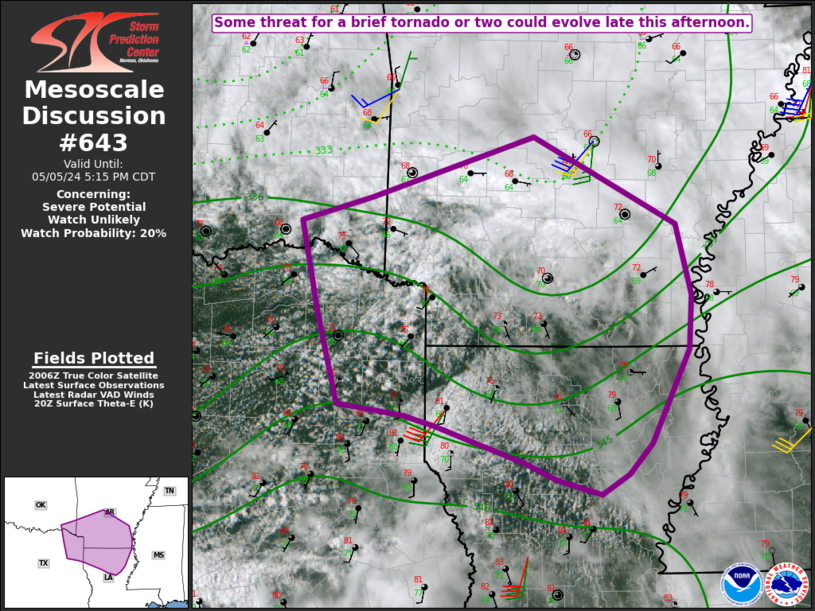
SPC MD 643MD 0643 CONCERNING SEVERE POTENTIAL...WATCH UNLIKELY FOR NORTHEAST TX/SOUTHEAST OK INTO NORTHERN LA AND SOUTHERN/CENTRAL AR
Mesoscale Discussion 0643
NWS Storm Prediction Center Norman OK
0314 PM CDT Sun May 05 2024

Areas affected...Northeast TX/southeast OK into northern LA and
southern/central AR

Concerning...Severe potential...Watch unlikely

Valid 052014Z - 052215Z

Probability of Watch Issuance...20 percent

SUMMARY...Some threat for a brief tornado or two could evolve late
this afternoon.

DISCUSSION...Clearing in the wake of earlier convection is allowing
for airmass recovery across northern LA and southern AR. Persistent
low-level theta-e advection in advance of a weak surface low across
northeast TX may allow for storm redevelopment later this afternoon,
within an effective warm frontal zone. With some midlevel drying
expected in the wake of the ejecting shortwave trough across AR, the
number and intensity of storms later this afternoon remains
uncertain. However, increasing moisture/instability and relatively
favorable low-level shear/SRH (as noted on the KSHV and KLZK VWPs)
could support brief tornado potential with any longer-lived cells
late this afternoon into early evening. Isolated hail and gusty
winds will also be possible.

At this time, the threat is expected to remain rather marginal and
isolated, rendering the need for watch issuance uncertain. Trends
will be closely monitored for the development of a supercell or two
later this afternoon.

..Dean/Smith.. 05/05/2024

...Please see www.spc.noaa.gov for graphic product...

ATTN...WFO...JAN...LZK...SHV...TSA...

LAT...LON   32409427 32499497 33299518 34129536 34329461 34869290
            34099140 33459123 32979126 32149166 31889191 31709220
            31829266 31979300 32149349 32309394 32409427
Read more
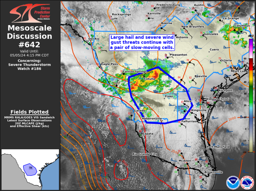
SPC MD 642MD 0642 CONCERNING SEVERE THUNDERSTORM WATCH 186... FOR SOUTH TX
|