


| WASHINGTON DC METRO AREA FORECAST DISCUSSION A slow-moving cold front will approach from the Midwest through tonight, then gradually cross the Mid-Atlantic from west to east through early next week. High pressure will likely return at least briefly for the middle of next week before another cold front approaches the area Thursday. |
Current DC Area Radar & North America Lightning
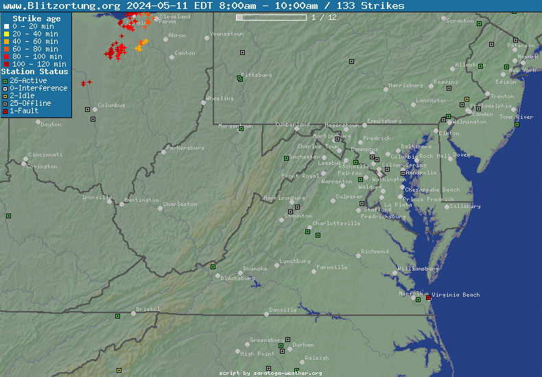
Northeast US Radar
|
North America Lightning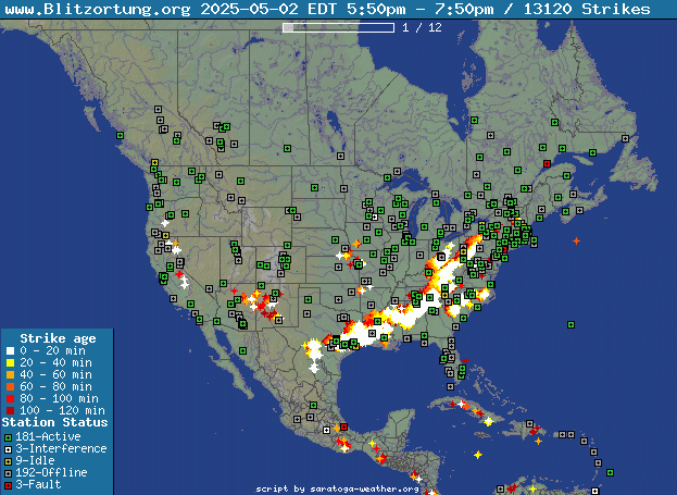
|
| Radar image courtesy of NWS. | Lightning Data courtesy of Blitzortung.org and its Contributors. |
Current Clifton Virginia Conditions & NWS Forecast
| Updated: @ 02-May-2025 8:20am - next update at 8:30am | ||||||||||||||||||||||||||||||||||||||||||||||||||||||||||||||||||||||||||||||||||||||||||||||||||||||||||||||||||||||||||||||||||||||||||||||||||||||||||||||||||||||||||||||||||||||||||||||||||||||||||||||||||||||||||||||||||||||||||||||||||||||||||||||||||||||||||||||||||||||||||||||||||||||||||||||||||||||||||||||||||||||||||||||||||||||||||||||||||||||||||||||||||||||||||||||||||||||||||||||||||||||||||||||||||||||||||||||||||||||||||||||||||||||||||||||||||||||||||||||||||||||||||||||||||||||||||||||||||||||||||||||||||||||||||||||||||||||||||||||||||||||||||||||||||||||||||||||||||||||||||||||||||||||||||||||||||||||||||||||||||||||||||||||||||||||||||
| Temperature | Summary | Outlook | ||||||||||||||||||||||||||||||||||||||||||||||||||||||||||||||||||||||||||||||||||||||||||||||||||||||||||||||||||||||||||||||||||||||||||||||||||||||||||||||||||||||||||||||||||||||||||||||||||||||||||||||||||||||||||||||||||||||||||||||||||||||||||||||||||||||||||||||||||||||||||||||||||||||||||||||||||||||||||||||||||||||||||||||||||||||||||||||||||||||||||||||||||||||||||||||||||||||||||||||||||||||||||||||||||||||||||||||||||||||||||||||||||||||||||||||||||||||||||||||||||||||||||||||||||||||||||||||||||||||||||||||||||||||||||||||||||||||||||||||||||||||||||||||||||||||||||||||||||||||||||||||||||||||||||||||||||||||||||||||||||||||||||||||||||||||||
|
|
|
||||||||||||||||||||||||||||||||||||||||||||||||||||||||||||||||||||||||||||||||||||||||||||||||||||||||||||||||||||||||||||||||||||||||||||||||||||||||||||||||||||||||||||||||||||||||||||||||||||||||||||||||||||||||||||||||||||||||||||||||||||||||||||||||||||||||||||||||||||||||||||||||||||||||||||||||||||||||||||||||||||||||||||||||||||||||||||||||||||||||||||||||||||||||||||||||||||||||||||||||||||||||||||||||||||||||||||||||||||||||||||||||||||||||||||||||||||||||||||||||||||||||||||||||||||||||||||||||||||||||||||||||||||||||||||||||||||||||||||||||||||||||||||||||||||||||||||||||||||||||||||||||||||||||||||||||||||||||||||||||||||||||||||||||||||||||


| NWS Weather Forecast - Outlook: Today & Tonight | ||||||
|
||||||
| NWS Weather Forecast - Five Day Outlook for Today through Tuesday - Last Update: Fri, 02-May-2025 7:30am EDT |
|
Today Mostly Sunny then Scattered Showers And T-Storms |
Tonight Isolated Rain Showers then Partly Cloudy |
Saturday Isolated Rain Showers then Scattered Showers And T-Storms |
Saturday Night Showers And T-Storms |
Sunday Showers And T-Storms |
Sunday Night  Showers And T-Storms |
Monday Showers And T-Storms |
Monday Night  Showers And T-Storms |
Tuesday Showers And T-Storms Likely |
| Hi 86 °F | Lo 65 °F | Hi 87 °F | Lo 65 °F | Hi 75 °F | Lo 63 °F | Hi 75 °F | Lo 62 °F | Hi 78 °F |
NWS Forecast Maps
NOAA Forecast Map for Today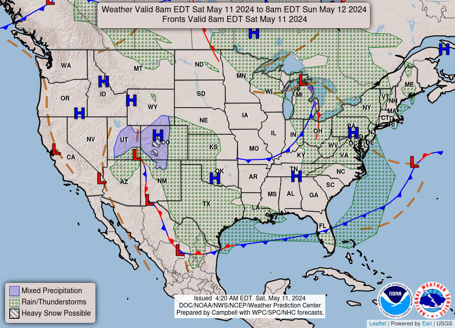
|
NOAA Forecast Map for Tomorrow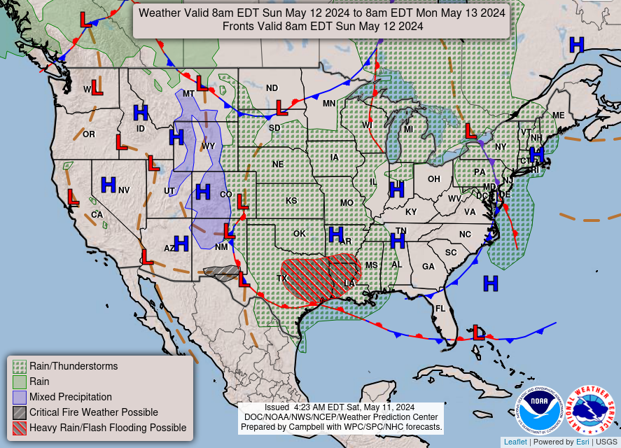
|
| Forecast map for Today courtesy of NOAA. | Forecast map for Tomorrow courtesy of NOAA. |
Random Weather Facts
|
Weather Terms Sleet - Sleet or ice pellets are solid grains of ice formed from the freezing of rain or the refreezing of melted snow, which bounce off the ground and other objects. |
Today in Weather History
|