


| WASHINGTON DC METRO AREA FORECAST DISCUSSION With convection forming earlier than expected, have made multiple updates to the forecast package to include this earlier timing. This has especially impacted the aviation forecasts for the 6 terminals across the region. Flood Watches remain in effect from the Blue Ridge westward. |
Current DC Area Radar & North America Lightning
Northeast US Radar
|
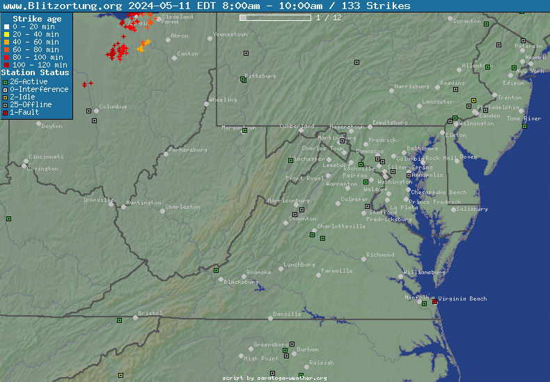
North America Lightning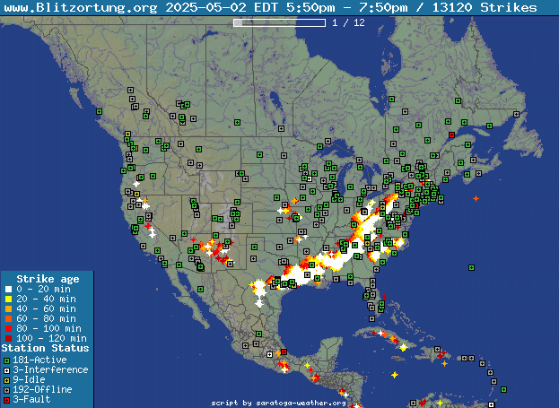
|
| Radar image courtesy of NWS. | Lightning Data courtesy of Blitzortung.org and its Contributors. |
Current Clifton Virginia Conditions & NWS Forecast
| Updated: @ 02-Aug-2026 4:10pm - next update at 4:20pm | ||||||||||||||||||||||||||||||||||||||||||||||||||||||||||||||||||||||||||||||||||||||||||||||||||||||||||||||||||||||||||||||||||||||||||||||||||||||||||||||||||||||||||||||||||||||||||||||||||||||||||||||||||||||||||||||||||||||||||||||||||||||||||||||||||||||||||||||||||||||||||||||||||||||||||||||||||||||||||||||||||||||||||||||||||||||||||||||||||||||||||||||||||||||||||||||||||||||||||||||||||||||||||||||||||||||||||||||||||||||||||||||||||||||||||||||||||||||||||||||||||||||||||||||||||||||||||||||||||||||||||||||||||||||||||||||||||||||||||||||||||||||||||||||||||||||||||||||||||||||||||||||||||||||||||||||||||||||||||||||||||||||||||||||||||||||||||
| Temperature | Summary | Outlook | ||||||||||||||||||||||||||||||||||||||||||||||||||||||||||||||||||||||||||||||||||||||||||||||||||||||||||||||||||||||||||||||||||||||||||||||||||||||||||||||||||||||||||||||||||||||||||||||||||||||||||||||||||||||||||||||||||||||||||||||||||||||||||||||||||||||||||||||||||||||||||||||||||||||||||||||||||||||||||||||||||||||||||||||||||||||||||||||||||||||||||||||||||||||||||||||||||||||||||||||||||||||||||||||||||||||||||||||||||||||||||||||||||||||||||||||||||||||||||||||||||||||||||||||||||||||||||||||||||||||||||||||||||||||||||||||||||||||||||||||||||||||||||||||||||||||||||||||||||||||||||||||||||||||||||||||||||||||||||||||||||||||||||||||||||||||||
|
|
|
||||||||||||||||||||||||||||||||||||||||||||||||||||||||||||||||||||||||||||||||||||||||||||||||||||||||||||||||||||||||||||||||||||||||||||||||||||||||||||||||||||||||||||||||||||||||||||||||||||||||||||||||||||||||||||||||||||||||||||||||||||||||||||||||||||||||||||||||||||||||||||||||||||||||||||||||||||||||||||||||||||||||||||||||||||||||||||||||||||||||||||||||||||||||||||||||||||||||||||||||||||||||||||||||||||||||||||||||||||||||||||||||||||||||||||||||||||||||||||||||||||||||||||||||||||||||||||||||||||||||||||||||||||||||||||||||||||||||||||||||||||||||||||||||||||||||||||||||||||||||||||||||||||||||||||||||||||||||||||||||||||||||||||||||||||||||


| NWS Weather Forecast - Outlook: This Afternoon & Tonight | ||||||
|
||||||
| NWS Weather Forecast - Five Day Outlook for This Afternoon through Thursday - Last Update: Sun, 02-Aug-2026 2:23pm EDT |
|
This Afternoon  Showers And T-Storms |
Tonight Showers And T-Storms |
Monday Chance Showers And T-Storms |
Monday Night Chance Showers And T-Storms |
Tuesday Mostly Cloudy |
Tuesday Night  Slight Chance Rain Showers |
Wednesday Slight Chance Rain Showers then Chance Showers And T-Storms |
Wednesday Night Chance Showers And T-Storms then Mostly Cloudy |
Thursday Partly Sunny then Chance Showers And T-Storms |
| Hi 82 °F | Lo 71 °F | Hi 85 °F | Lo 67 °F | Hi 84 °F | Lo 68 °F | Hi 86 °F | Lo 71 °F | Hi 88 °F |
NWS Forecast Maps
NOAA Forecast Map for Today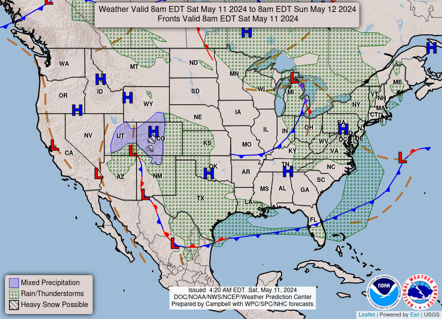
|
NOAA Forecast Map for Tomorrow
|
| Forecast map for Today courtesy of NOAA. | Forecast map for Tomorrow courtesy of NOAA. |
Random Weather Facts
|
Astronomy One year on Mercury is only 88 days. |
Today in Weather History
|